Horseshoe Bend
Colorado River's dramatic horseshoe curve from above
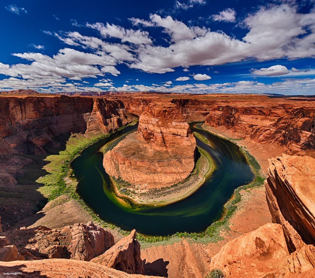
That photo you've seen a thousand times on Instagram? This is where it comes from. Horseshoe Bend sits just outside Page, Arizona, where the Colorado River makes a perfect 270-degree turn around a massive sandstone cliff. The viewpoint perches 1,000 feet above the water, offering one of the Southwest's most recognizable vistas. But here's what the photos don't show you: the short hike to get there, the crowds that gather at sunset, and the fact that there's no railing between you and a very long drop. It's simultaneously one of Arizona's most accessible natural wonders and one that demands respect.
Culture & Context
DINÉ HOMELAND SACRED
Horseshoe Bend sits within the Glen Canyon National Recreation Area, just a few miles from the Navajo Nation boundary — one of the largest Indigenous territories in the US, spanning 27,000 square miles across Arizona, Utah, and New Mexico. The Diné (Navajo people) have called this region home for centuries. Antelope Canyon, just 7 miles away, is on Navajo land and can only be visited with authorized Navajo guides — those guides are storytellers and cultural stewards, not just tour operators.
Page itself was founded as a company town for construction workers building the Glen Canyon Dam in the 1950s and has since grown into the primary hub for Southwest adventure tourism. The town sits right at the edge of Navajo territory, so many of the tour operators, restaurants (like Red Heritage, which features live Navajo dancers and fry bread), and artisan vendors are Navajo-owned. Supporting those businesses directly benefits the community.
The Diné call the land "Diné Bikéyah" — a homeland they consider sacred. Visitors are welcomed warmly, but the culture emphasizes respect for the land, privacy, and not treating sacred sites as photo backdrops.
Local Customs
STAY BEHIND RAILING
Always stay behind the safety railings at the overlook — the drop is 1,000 feet and fatal falls have occurred. The central viewing platform has a railing; the rim on either side does not.. Bring at least 1 liter of water per person per two hours.
In summer, temps hit 110°F and the trail has zero shade. This is not a casual stroll without water.. On major holidays (Memorial Day, Labor Day, July 4th, Thanksgiving, Christmas), the parking booth goes cash-only.
Have bills ready to avoid long waits in line.. Your America the Beautiful National Park Pass does NOT work here. The parking lot is City of Page property, not federal land.
$10 per vehicle, full stop.. Dropping people off at the trailhead on Hwy 89 is illegal and will be ticketed. Parking on the highway shoulder is also illegal.
If the lot is full, you wait or come back.. Antelope Canyon requires booking a Navajo-authorized guided tour in advance — often months ahead in spring and fall. Walk-ins don't exist..
On Navajo Nation land (which includes Antelope Canyon), ask permission before photographing any person. Drone photography is prohibited on tribal lands.. Rock climbing and removing any natural objects are strictly prohibited on Navajo Tribal Park lands — treat all rocks and formations as off-limits to touch or take..
If you visit the Navajo Nation, be aware it observes Daylight Saving Time even though Arizona does not — when it's 2pm in Page, it's 3pm on the Navajo Nation.. Pets are allowed on the Horseshoe Bend trail but must stay on leash. The desert heat can be brutal for animals — bring water for them too..
Leave No Trace is taken seriously. Pack out everything you pack in.
Safety
CLIFF EDGE DEADLY
The most serious risk at Horseshoe Bend is a fall from the 1,000-foot cliff edge. Fatal falls average 2-3 per year — typically involving visitors who climbed outside the safety railing for a photo. The central viewing platform has sturdy metal railings.
The rim on either side does not. One strong gust of wind can knock someone off balance near an unguarded edge. Stay behind the railing, period.
No photo is worth the risk. Heat is the second major hazard. Summer temperatures regularly exceed 100-110°F and the trail has zero shade.
Bring at least 1 liter of water per person per two hours. Heatstroke is a real risk, especially on the exposed return hike uphill. Wear sun protection and closed-toe shoes — the sandy, rocky trail is uneven.
The Colorado River at the bottom looks serene but has strong, unpredictable currents. Do not attempt to access the river from the overlook area. Dogs are welcome on leash but need water too.
In summer, pavement and sand can burn their paws — carry water for them. From a crime and safety standpoint, Page is a small, safe tourist town. The site itself is well-staffed and maintained.
Standard precautions apply: don't leave valuables in your car, and be aware of your surroundings in the parking lot during busy peak-season days.
Getting Around
CAR REQUIRED ESSENTIAL
There is no public transit to Horseshoe Bend — a car is essentially mandatory. Page Municipal Airport (PGA) handles small regional flights, but most visitors drive in. From Las Vegas it's about 4.
5 hours (270 miles) via US-89. From Phoenix it's roughly 4 hours (270 miles) via US-89 north through Flagstaff. From Flagstaff, it's a straight 2.
5-hour shot north on Hwy 89 — watch for the parking lot on the west side of the road at mile marker 544, just before entering Page. The Horseshoe Bend parking lot is off US-89, about 5 miles south of downtown Page. GPS works reliably for this leg.
Parking costs $10 per vehicle (cash or card; cash-only on major holidays). RVs and buses have designated spaces. Do not park on Hwy 89 — it's a 65 mph highway and the city actively tickets and tows violators.
Dropping passengers off at the trailhead is also prohibited. Lake Powell Taxi Services provides private SUV transportation around Page, Big Water, Utah, and surrounding areas — useful for early morning Antelope Canyon departures or airport transfers. Antelope Canyon tours (7 miles away) provide their own transport from designated meeting points near Page — confirm your exact check-in location when booking.
For the region at large, a rental car with decent ground clearance opens up slot canyons, Grand Staircase-Escalante, and Monument Valley. Some backcountry roads are rough enough to warrant high clearance.
Useful Phrases
Itineraries coming soon
We're working on adding amazing itineraries for Horseshoe Bend. In the meantime, try the app to create your own!
Money-Saving Tips
- 1.Park at the official lot for $10 rather than risk a ticket on Highway 89 - rangers patrol regularly
- 2.Fill up gas in Page before heading out - it's the last stop for reasonable fuel prices
- 3.Pack your own water and snacks instead of buying at nearby tourist shops where a bottle costs $4
- 4.Visit during summer for cheapest hotel rates in Page, just start your hike before dawn
- 5.Consider camping at Wahweap to save on lodging - sites cost $30/night versus $150+ for Page hotels during peak season
Travel Tips
- •Start your hike before 9 AM to avoid crowds and secure parking
- •Stay back from the cliff edge - there are no railings and the sandstone can crumble
- •Bring a polarizing filter for photos to cut glare off the Colorado River
- •Download offline maps before going - cell service is spotty on the trail
- •Wear closed-toe shoes with good grip for the sandy sections of trail
- •Check weather before going - flash flood warnings affect the area even when it's sunny
- •Bring a headlamp or phone light for the walk back after sunset viewing
Frequently Asked Questions
Explore Horseshoe Bend
BUILD YOUR
HORSESHOE BEND PLAN
Insider picks, smart timing, and a plan ready when you are.
Start Planning