Crater Lake
America's deepest lake in a volcanic caldera wonderland
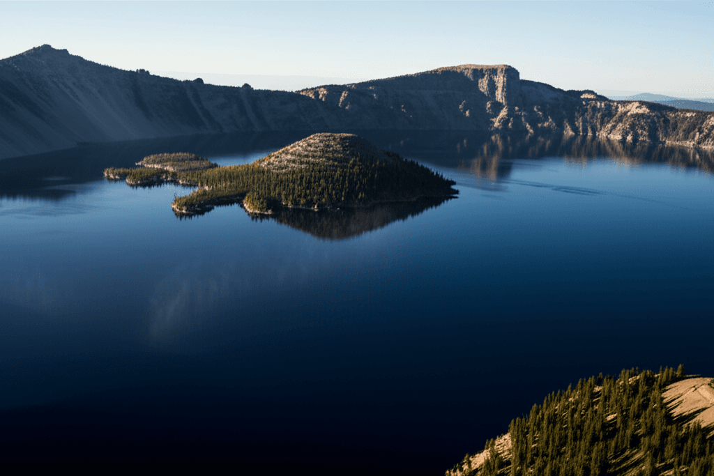
Crater Lake sits like a sapphire in the heart of Oregon's Cascades, filling a caldera left behind by Mount Mazama's collapse 7,700 years ago. At 1,943 feet deep, it's the deepest lake in the United States and one of the clearest bodies of water on Earth. The lake's impossible blue comes from its depth and purity — no streams flow in or out, just snowmelt and rain.
But here's what the postcards don't tell you: Crater Lake National Park closes most of its roads for half the year. Snow can linger until July, and the famous Rim Drive doesn't fully open until late June or early July most years. When it does open, though, you get 33 miles of volcanic rim views that'll make you pull over every quarter mile.
The park gets busy in summer — really busy. July and August bring crowds that can make parking at popular viewpoints a challenge by 10 AM. But venture beyond the main overlooks, and you'll find quieter spots where you can sit with just the lake and the occasional Clark's nutcracker for company.
Best Months
JUN – SEP
~20°C · moderate crowds
Culture & Context
SACRED CALDERA COLLAPSE
Long before any park ranger handed you a trail map, this lake was known as Giiwas by the Klamath Tribes — the Klamath, Modoc, and Yahooskin peoples — who understood what happened here 7,700 years ago better than any geologist would for millennia. Their oral tradition describes witnessing the catastrophic collapse of Mount Mazama (Moy-yaina, or "Big Mountain") into a caldera, and that story matches the geological record almost exactly. The lake was considered so sacred that tribal members kept its existence deliberately secret from outsiders for thousands of years.
When the Klamath Tribes signed the Treaty of 1864, Giiwas was supposed to be inside the protected boundary. It wasn't honored. On May 22, 1902, it became a national park.
The Klamath Tribes still hold the lake sacred and continue to ask visitors to approach it with respect. That context matters when you're standing at the rim. The park is also Oregon's only national park.
It sits in the Cascade Range of southern Oregon, reachable via Highway 62 from the west/south or US-97 from the east. The nearest city is Klamath Falls, about 37 miles south.
Local Customs
RESPECT THIS SACRED LAKE
The park is fully cashless at entrance gates. Pay by card or pre-purchase a pass at Recreation.gov before you go.
Showing up with cash won't get you in.. Rim Drive is a one-way loop in sections — drive it clockwise. The speed limit is 35 mph on the narrow mountain road.
Don't rush it; it takes 2–4 hours with stops.. Bear-resistant food lockers are at every campsite at Mazama. Use them — every time, even for a quick hike.
Around 30–40 black bears live in the park.. Lodge rooms at Crater Lake have no TVs and no room phones by design. The whole operation is geared toward getting you outside and offline.
Plan accordingly.. Fishing is actively encouraged in Crater Lake. The fish (kokanee salmon and rainbow trout) were stocked non-natively starting in 1888 and now maintain a self-sustaining population.
No fishing license required inside the park.. Treat the lake with respect — this is still a sacred site to the Klamath Tribes. Keep noise down at overlooks, pack out everything you bring in, and stay on marked trails.
Leave No Trace isn't just a slogan here.. Make dinner reservations at the Lodge Dining Room at least a week in advance. Tables with lake views go to larger parties — couples often end up against the back wall.
If that bothers you, grab drinks and apps on the Great Hall terrace instead, which has some of the same views.. The park is operating with significantly reduced staff in 2026 due to federal hiring freezes and vacancies in key positions. Ranger-led programs are happening but the schedule is uncertain.
Check the NPS website before banking on specific programming.
Safety
UNSTABLE VOLCANIC TERRAIN
2026 brings specific risks beyond the usual. The Cleetwood Cove Trail is closed and fenced off — do not attempt to reach the lake by descending the caldera walls anywhere else. People have done this and needed rescue. The cliffs are unstable volcanic rock and loose pumice. Construction vehicles are operating on sections of Rim Drive, particularly East Rim Drive beyond Skell Head. Use caution and watch for traffic if you hike or bike past the Skell Head gate. The park is operating with fewer rangers than normal in 2026 due to federal staff cuts and an ongoing hiring freeze for permanent positions, including the chief ranger role. That means slower emergency response times in remote areas.
General hazards year-round: weather changes fast at 6,000+ feet, and snow can fall any month including July and August. Pack warm layers even for summer hikes. Afternoon thunderstorms can roll in quickly. There is essentially no cell service in most of the park — tell someone your itinerary before heading into the backcountry. Black bears (30–40 in the park) are active; use bear-resistant lockers at all campsites. Unstable snow ledges extend beyond the rim edge in winter and early spring — the NPS has a short safety video about them on their website worth watching if you visit outside of peak summer season.
Getting Around
RENT A CAR
There is no public transit to Crater Lake. A car is essential. From Medford (the nearest airport, served by major carriers) it's about 75 miles northeast on Highway 62 — roughly 1.5 hours depending on traffic and road conditions. From Klamath Falls, take US-97 north to Highway 62 west; about 55 miles and an hour. The south entrance via Highway 62 and the Annie Springs entrance station is the main approach.
Inside the park, Rim Drive is the main route — a 33-mile loop circling the caldera. Drive it clockwise. It's narrow and winding with a 35-mph speed limit. Budget 2–4 hours if you actually stop at viewpoints, which you should. Portions of East Rim Drive are currently closed due to rock slides and the road rehabilitation project.
A trolley tour runs from Rim Village in summer — it's a legitimate way to see the rim without the stress of driving narrow roads, and the onboard guide is knowledgeable. Worth it if tight parking or winding mountain roads aren't your thing.
The park entrance gates are cashless. Pre-purchase a pass at Recreation.gov or buy on-site by card. There is no cell service at the south entrance gate, so download or print your pass before arriving.
Useful Phrases
Money-Saving Tips
- 1.Buy the America the Beautiful Annual Pass ($80) if visiting multiple national parks — it pays for itself after three park visits
- 2.Pack your own lunch and snacks — the lodge restaurant is pricey and limited options exist in the park
- 3.Fill up your gas tank before entering the park — no gas stations inside and nearest stations are 30+ miles away
- 4.Book Crater Lake Lodge a year in advance for best rates, or check for last-minute cancellations in shoulder seasons
- 5.Camp at Mazama Campground ($23/night) instead of staying at the lodge to save $150+ per night
- 6.Visit in September after Labor Day for lower accommodation rates and fewer crowds
- 7.Bring a National Parks Senior Pass if you're 62+ — it's $80 for lifetime access vs $30 per visit
Travel Tips
- •Download offline maps before visiting — cell service is spotty throughout the park
- •Start early to beat crowds at popular viewpoints like Rim Village and Watchman Overlook
- •Bring layers even in summer — temperatures can drop 40 degrees from afternoon to evening
- •Check road conditions before your trip — Rim Drive doesn't fully open until late June most years
- •Pack extra water and snacks for hikes — the elevation (6,000+ feet) can be more tiring than expected
- •Book boat tours to Wizard Island as soon as reservations open in May — they sell out quickly
- •Visit the Steel Visitor Center first for current trail conditions and weather updates
- •Bring cash for some park services and nearby businesses that don't accept cards